- Title
- District Boundaries of Zambia
- Abstract
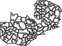
This feature represents the 115 districts of the Republic of Zambia. District boundaries are mapped by the Ministry of Lands and Natural Resources (MLNR) through the Office of the Surveyor General.
Initially, Zambia had 74 districts. However, 41 new districts were created between 2011 and 2019. These districts were created by splitting already existing large districts into 2 or more. The main drivers to the splitting of these districts were to ease management and decentralization. Each new district has a municipal council and District Commissioner who are responsible for administration and management of district resources.
Source: Ministry of Lands and Natural Resources (MLNR) and the National Remote Sensing Centre (NRSC).
- License
- Not Specified
-
+ The original author did not specify a license.
- Publication Date
- Jan. 21, 2020, midnight
- Type
- Vector Data
- Keywords
- districts features REQUIRED: Common-use word or phrase used to describe the subject of the data set.
- Category
- Boundaries
- legal land descriptions. Examples: political and administrative boundaries
- Regions
- Global, Africa, Southern Africa, Zambia
- Approved
- Yes
- Published
- Yes
- Featured
- No
- Group
- RISK PROFILES
- Name
- Michael Phiri (michael.phiri)
- Position
- Organization
- Zambia
- Location
- Voice
- Fax
- Identification Image
-
- Spatial Extent
- ---
- Projection System
- EPSG:4326
- Extension x0
- 21.980037939000100
- Extension x1
- 33.712437939000000
- Extension y0
- -18.079176286999900
- Extension y1
- -8.271976286999970
- Restrictions
- This dataset has no restrictions
- Purpose
This dataset was developed to show the delineation of districts in Zambia
- Language
- English
- Data Quality
- This data was acquired from the Ministry of Lands and Natural Resources who are mandated to create administrative boundaries in Zambia
- Supplemental Information
No information provided
- Name
- Michael Phiri (michael.phiri)
- Position
- Organization
- Zambia
- Location
- Voice
- Fax
- Link Online
- /layers/geonode:districts
- Metadata Page
- /layers/geonode:districts/metadata_detail
- JPEG
- District Boundaries of Zambia.jpg
- District Boundaries of Zambia.pdf
- PNG
- District Boundaries of Zambia.png
- Zipped Shapefile
- District Boundaries of Zambia.zip
- GML 2.0
- District Boundaries of Zambia.gml
- GML 3.1.1
- District Boundaries of Zambia.gml
- CSV
- District Boundaries of Zambia.csv
- Excel
- District Boundaries of Zambia.excel
- GeoJSON
- District Boundaries of Zambia.json
- KML
- District Boundaries of Zambia.kml
- View in Google Earth
- District Boundaries of Zambia.kml
- Remote Thumbnail
- District Boundaries of Zambia.png
- Thumbnail
- District Boundaries of Zambia.png
- Legend
- District Boundaries of Zambia.png
- OGC WMS: geonode Service
- Geoservice OGC:WMS
- OGC WFS: geonode Service
- Geoservice OGC:WFS
- Name
- Michael Phiri (michael.phiri)
- Position
- Organization
- Zambia
- Location
- Voice
- Fax